Home » About Sarawak » Geography » Geographical Location

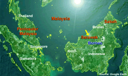
Sarawak is located on the western region on the island of Borneo. Covering an area of 124,449.51 square kilometers, it is the largest state in Malaysia, making up some 37.5% of the country's total area of 329,750 sq km.
Located immediately north of the Equator between latitude 0° 50° and 5°N and longitude 109° 36' and 115° 40' E, Sarawak stretches some 800km along north-west coast of the island of Borneo. Sarawak is separated from Peninsular Malaysia by a distance of 600 km by the South China Sea. On the island of Borneo, it directly adjoins the State of Sabah to the north-east where the Sultanate of Brunei forms a double enclave. Inland, the State borders with Kalimantan, Indonesia.

About Us
Privacy Policy
Copyright Notice
Sitemap
Terms and Conditions
Feedback / Comment
FAQ
Contact Us
Copyright ©2010 Sarawak Government
Disclaimer: The Government of Sarawak shall not be liable for any loss or damage caused by the usage of any information obtained from this portal. Services provided through this portal are subject to the terms and conditions of the respective service providers.
Best viewed with Netscape and Mozila Firefox; Screen resolution 1024 by 768 pixels